


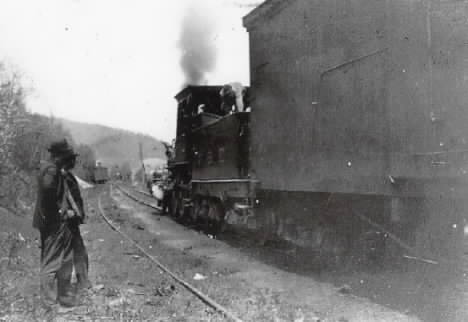
At State Line in 1900, CNE 4-4-0 16 and its train are heading west off the west leg of the wye to get to Millerton ; even though the train is coming from the west in the first place. CNE trains used the most northerly route through Silvernails and Copake from the west (see map), because the P&E route (via Ancram Lead Mines) and the ND&C route (via Shekomeko) were not taken over by the CNE until 1907.
J. W. Swanberg collection
**********

MAP: Canaan to State Line in 1932.
This was in deepest depression years, when through traffic on the ex-CNE had dried up, and when the New Haven did not even operate the portion from State Line to Copake.
J. W. Swanberg collection
**********

State Line wye looking west toward Millerton.
The shanty was probably used for the register board. Tracks at right run north to Boston Corners This was in September 1938, barely two months after abandonment.
Photo by the late Joseph McMahon Sr.

State Line at the north end of the wye looking south.
September 1938
To the left is to Lakeville and right is to Millerton.
Photo by the late Joseph McMahon Sr.

Terraserver photo of State Line.
State Line Road is the Y shape across the center of the photo. The New York/Connecticut line runs up through the center crossing the road where it splits. The CNE roadbed shows as a line of trees across the lower half. Millerton NY is to the left and Canaan Ct is to the right. The line north to Boston Corners and Copake goes northwest off the top left corner. You can clearly see the outline of the wye with oil company buildings and tanks in the middle. State Line Road is the Y shape across the center of the photo. The New York/Connecticut line runs up through the center crossing the road where it splits. The CNE roadbed shows as a line of trees across the lower half. Millerton NY is to the left and Canaan Ct is to the right. The line north to Boston Corners and Copake goes northwest off the top left corner. You can clearly see the outline of the wye with oil company buildings and tanks in the middle.

Mt. Riga Station on a sunny day in September 1938. Tracks to the right of the station are NYC Harlem line. CNE tracks were on the left side of the building.
Nimke Volume 3 Page 103

CNE was not using their tracks at Mt Riga in November 1932. Line was abandoned in 1938.


A series of drawings was done by Vic Westman to be published in a book by Bob Adams. Adams passed away before the book was completed and it was never published. Adams made some of the drawings into Christmas cards.
Heyward Cohen Collection
**********
Boston Corners
**********

Boston Corners Station in 1907 when all three lines were in operation. At left is the former P&E and in the center is the former R&C, both now part of the CNE. On the right is the NYC Harlem. The train in the center is the CNE Sunday, Campbell Hall to Hartford run of train No. 202.
Nimke Volume 2 Page 135
P&E third #4 at Boston Corners.
Lee Beaujon Collection P&E third #4 at Boston Corners.
Lee Beaujon Collection

When the CNE took over the P&E, one of the top priorities was to fill in the old wobbly trestle at Halsteads before winter weather set in. The gravel came from the site of the wye just south of Boston Corners.
Nimke Volume 2 Page 16

CNE #26 wrecked at Boston Corners 11 April 1902.
Lee Beaujon Collection

At far left is a CNE work train on the former P&E tracks. Tracks just to the left of the station are fomer R&C. Tracks at right are the NYC Harlem line. At lower right is the target stop signal controlling the diamond.
Nimke Volume 3 Page 105

Here is a trackside view of the target signal at the diamond about 1923. This time it is set to allow the CNE to cross. Gates were normally set against the CNE trains and were opened only when required.
J Swanberg Collection

Boston Corners in 1932 looking north along the NYC Harlem line. Notice in the lower right corner, the crossing diamond has recently been removed. There are ties still scattered on the ground and fresh ballast on the Harlem line.
J Swanberg Collection

Closer view of the spot where the diamond was removed in 1928.
Lee Beaujon Collection

Another view before the old frogs were picked up.
Lee Beaujon Collection

CNE #34 at Boston Corners about 1903.
J Swanberg Collection CNE #34 at Boston Corners about 1903.
J Swanberg Collection

Boston Corners Station – 1937. The CNE tracks were to the left across a gully and reached by a wooden footbridge.
Fran Donovan Collection

Boston Corners Station. Tracks in the foreground are the NYC Harlem line. Abandoned CNE tracks were to the left of the station.
Lee Beaujon Collection

Here is the CNE side of the station.
Nimke Volume 3 Page 104

This locomotive was built by Rogers locomotive Works in Paterson New jersey in 1871. It became C&W #1 – then CNE&W #1 – later PR&NE #1 – Scrapped in 1893
Fran Donovan collection

Conductor Russell’s report for train #54 from Boston Corners to Hartford with 18 cars on 2 September 1890.
Fran Donovan colletion

If you take a long view at a map of Columbia County, you will notice in the extreme southeastern corner, just above the Dutchess County “Oblong,” an appendage that looks like the proverbial sore thumb. Like the proverbial sore thumb it was not always there. Unlike the sore thumb, it took an Act of Congress to put it there. The little area consists of 1,000 acres of farmland and is known as Boston Corners.
Today there is nothing very remarkable about Boston Corners, it is a serene little community nestled in the Taconic Hills. It consists of farms, a few roads and was once a stop on the New York Harlem Railroad.
Boston Corners may be a peaceful and tranquil setting today but that was not always the case. There was a time in the nineteenth century when it could rival the legendary “Hole in the Wall” made famous by Butch Cassidy and the Sundance Kid. That was a time when it was not part of New York State, much less Columbia County. It was part of the Commonwealth of Massachusetts.
Boston Corners sits above “the Oblong” of the Town of Northeast like a pointed dunce’s cap. (See the map.) Historically it lay in the southwestern part of Massachusetts and was as far removed from its namesake capital as its geographical situation would allow. Besides that, Massachusetts was unable to enforce its jurisdiction on the little community. The highest peaks of the Taconic Hills on the west and the Connecticut line to the south made it inaccessible to that state’s law-enforcement authorities as well as its courts and jails.

Map showing old boundary line, running approximately from Alander Mountain southwest to Boston Corners. (From Columbia County, 1976, courtesy Green River Gallery.)
This was not all bad for Boston Corners; due to lack of law-enforcement the good citizens ran things as they saw fit. Because of their isolation, they did not vote in state elections, nor did they pay state taxes, they supported their own schools. Having neither jail, judge nor jury, they felt they were getting on all right as things were.
In his 1909 History of Dutchess County Frank Hasbrouck said, “Had they been left to themselves their escutcheon might have remained untarnished.” But that was not the case which accounted for a stain on their escutcheon.
An enterprising gentleman from New York City, by the name of Samuel Black, came into their midst. This gentleman saw all kinds of possibilities in Boston Corners. The New York Harlem Railroad was under construction from Amenia and Millerton, and there were stations planned for Boston Corners and Copake. A little above Copake, Mr. Black opened “Black’s Grocery” to accommodate the local people, also an inn and tavern for the benefit of out-of-towners. The inn and tavern did a better business than the grocery as the visitors from the seedier side of the tracks found their way to Mr. Black’s establishment; and Mr. Black prospered. With the coming of the railroad many of his guests came from New York City. In his History of Dutchess County Frank Hasbrouck referred to Black’s clientele as “refugees from the constables of three commonwealths.”
Guests came and went; duels were common; gambling was the order of the day and lawlessness inhabited the land. At this time the sport of boxing was illegal. Prize fights were held in such places as barges, warehouses or any place that seemed to be beyond the law. The location of Boston Corners being ideal for the illicit side of life was a perfect place, and well-suited for prize fighting.
On Wednesday, October 12, 1853, an event took place that would change the face of Boston Corners forever. On that date a brash young fighter from Troy, N.Y., by the name of John Morrissey challenged the famed Yankee Sullivan. Sullivan, age 40, weighed 145 pounds, giving away 30 pounds to the younger Morrissey. Morrissey who was 22 years old, stood 6 foot 2 inches and weighed 175 pounds. The purse for the winner was $2,000 and the fight was held in an abandoned brickyard. Today there is a historic marker at the site, on Undermountain Road just north of the Dutchess County line. Unfortunately the date on the marker—1883—is incorrect. It was estimated that between three and five thousand fight fans converged on Boston Corners the day of the fight. They came from New York City, Albany, Troy and all points in between. Little thought was paid to the fact that the population of Boston Corners was less than 150 people and had only one inn. The fans came; they came by train, by stage, by horse and on foot; all converging on the little hamlet to see what was hoped to be the fight of the century. By fight time many of the fans were well tanked up from liquor they either brought with them or bought on their way south from Black’s Inn. They were not considered the most genteel crowd that ever assembled. An aura of rowdiness hung over the event.
Morrissey was not a skilled boxer but a brawler who was considered a favorite over Sullivan. From the beginning of the fight Sullivan displayed his boxing skill against his young and bigger opponent. By the end of the first round Morrissey’s left eye was blackened and blood was coming from his nose. Each of the following rounds were repeats of the first with Sullivan badly punishing Morrissey. For thirty-six grueling rounds Sullivan beat his heavier opponent, but Morrissey refused to stay down. In the 37th round, as Sullivan tried to throw Morrissey to the floor, both fighters’ handlers charged into the ring and there was a free-for-all. In an attempt to restore order, the referee called the fighters to the center of the ring to resume the fight. Morrissey responded, but in the confusion Sullivan failed to answer the referee’s call. The referee declared Morrissey the winner with the title of “Champion of America.”
What happened next has become known as “The Sack of Millerton” (though it all took place several miles north of that benighted village). A melee broke out in the crowd at the referee’s decision. The riot spilled out of the brickyard into neighboring farms. The rioters started looting on their way back to the train. Farms were ransacked, pantries were looted for food, hogs were slaughtered and roasted along the road. The Boston Corners community was stripped of every edible thing that could be found. Some local people managed to flag down a freight train to take them to a safer location.
New York authorities moved in to restore order and arrested the most innocent of the crowd, the two boxers. The boxers were held on $1,500 bail each. Sullivan jumped bail and was last heard of on the West Coast. Morrissey paid a $1,200 fine and became the toast of New York. He made friends with the Tammany Hall politicians who controlled New York City politics. The “famous fight” changed Boston Corners forever. The good citizens petitioned to New York State and the U.S. Congress to bring them into the jurisdiction of New York. On January 3, 1855 an Act of Congress changed the state line and made Boston Corners officially part of New York. Meanwhile, John Morrissey became a respected citizen. He married a highly-educated young lady who urged him to change his ways and develop good personal habits. He fought once more in 1858, when he successfully defended his title against John Heenan.
After the birth of his son, Morrissey moved with his family back to Troy, where he entered politics. He was twice elected to the U.S. House of Representatives and twice to the U.S. Senate. He was a gambler and was involved in gambling establishments in New York City and Saratoga including the famous Saratoga race track.
In 1877 Morrissey became ill during his second campaign for the U.S. Senate. He won the election but never took his seat. He died at the Adelphi Hotel in Saratoga Springs on May 1, 1878, at the age of 47. An estimated crowd of 12,000 stood outside the church in Troy to pay their respects to an American Champion.
***********
Copake
**********

H&CW #17 at Copake. H&CW RR operated the line from 1882 to 1889.

Postcard view of Copake Station dated August 1920.

Copake Station looking east in September 1927.
Lee Beaujon Collection

Copake Station on a rainy day in March 1932.
These gasoline powered rail buses were used in place of steam trains for the last few years of passenger service. They ran to Poughkeepsie in the morning and returned in the afternoon. Rail Bus #9020 was a Brill car built in 1925 that had a 120 hp gasoline engine and a manual transmission similar to trucks. Service was discontinued by the NH RR in September 1933.

Copake Station in 1993.
Photo by J W Swanberg

Copake Station in 1999
Photo by Lee Beaujon

Poughkeepsie & Eastern RR #2 named “Olivia” built by Rogers in 1893.
Became CNE #204 and was scrapped in 1913.
Fran Donovan collection
Notice that the front coupler is slotted to accept link and pin couplings. It also has air brake lines. Just behind the front coupler is the wooden “armstrong” handle used to move the turntable. There is a second handle to the left of the tender.

Trestle at Halsteads being filled by gravel from Boston Corners wye.
Nimke Vol 2 Page 16

Many train loads of gravel were needed to fill in the trestle at Halsteads.
Nimke Vol 2 Page 21
Before filling this trestle was 66 feet high.
**********
ANCRAM
**********

This station was originally called Ancram Lead Mines but the name was changed to Ancramdale in the 1920’s.
Publication # 1 of the Roeliff Jansen Historical Society Page 23

Former P&E station at Ancramdale 6 Sept 1927.
Lee Beaujon Collection

Ancram station on 2 July 1938, just months before abandonment.
Nimke Volume 3 Page 111

This siding at Ancram served the H. U. Rockefeller coal and feed business.
Nimke Volume 3 Page 111
**********
Pine Plains
**********

PINE PLAINS – Former P&E Ry station looking West with NH RR Class K-1 locomotive #392 (2-6-0) about ready to depart for Ancramdale. Photo taken by former CNE fan Thomas B. Annin in Nov., 1932. This station stopped being used as a passenger station after the P&E was taken over by the CNE in 1907 and all trains went to the CNE (former ND&C line) station after that. It was necessary to make a back-up move from ND&C Jct. to the station when this was done and, of course, the reverse was done for trains headed for Boston Corners and beyond. In the late 1920’s and early 1930’s, this station building was office of the area’s Track Supervisor.
Lee Beaujon collection

P&E station at Pine Plains looking east.
Nimke Vol 3, p 141

PINE PLAINS – P&E Jct. which was located about 1/7th of a mile North of ND&C Jct. Track to left went to the former P&C RR at West Pine Plains and beyond north to Silvernails, Copake, Boston Corners and Millerton via State Line. Line to right was the old P&E Ry line to Boston Corners and Millerton via State Line. This connection between the lines was built after the CNE took over the former P&E Ry in 1907.
Photo taken in May, 1937 about a year before abandonment.
Lee Beaujon collection

1892 pass for the ND&C RR and the Clove Branch RR.
B L Rudberg collection
**********
SILVERNAIILS
**********

Mr. and Mrs. Martin Wheeler and guest at Silvernails.
Martin Wheeler – William P. Fahey collection

Silvernails agent Martin Wheeler by the locomotive “General” at the New York Worlds Fair 24 Sept. 1939
One year after Silvernails station closed.
Martin Wheeler – William P. Fahey collection

Martin Wheeler – William P. Fahey collection


F B Ficher and Steve Masten at Silvernails about 1909.
The boy in the cab is Ray Wheeler, son of Silvernails agent Martin Wheeler.
Martin Wheeler – William P. Fahey collection

This water column still stands at the north end of where the CNE yard used to be. It is now a dirt road on a horse breeding farm. The farm owner preserves the water column and had it painted in honor of our 2004 CNE Spring tour visit.
B. L. Rudberg Photo

H&CW #3 in 1885. Built by Rogers in 1871.
Fran Donovan collection

SILVERNAILS – Northeast view of station (with Agent Martin J. Wheeler out front) as taken by former CNE fan Thomas B. Annin in Summer of 1935. Wheeler started work with the H&CW RR in the Silvernails station beginning in 1889 and remained there until the lines through the area were abandoned in July, 1938. After abandonment he bought the station and lived in it.
Lee Beaujon collection

SILVERNAILS – Track diagram as drawn up by former CNE fan Robert B. Adams. There is an error, however, in his location of the old turntable. Old railroad issued track diagrams show the turntable as having been located between the main line and the north leg of the wye track.
Lee Beaujon collection

Eastbound arriving at Silvernails from Rhinecliff.
Nimke Volume 2, Page 65
**********
ELIZAVILLE
**********

Railroad building along the former CNE roadbed near Mt Ross.
B. L. Rudberg photo

The abutments for bridge 15.53 remain along the Roeliff Jansenkill near Mt Ross. This is a popular fishing area and is stocked with trout every spring. There is easy walking access along the former CNE roadbed. B. L. Rudberg photoThe abutments for bridge 15.53 remain along the Roeliff Jansenkill near Mt Ross. This is a popular fishing area and is stocked with trout every spring. There is easy walking access along the former CNE roadbed. B. L. Rudberg photo

Elizaville station is now a private residence.
Photo by the late Austin McEntee

Photo by the late Austin McEntee
**********
COKERTOWN (SPRING LAKE)
**********

This station was originally Spring Lake but the name was changed to Cokertown in the 1890’s The water tower was supplied by an artesian well that can produce as much as 1000 gallons per minute. The well is still in use to supply tanker truck loads of clean water for businesses and swimming pools etc. For many year this station was closed during the spring and summer. It opened in the fall and winter for the ice harvesting season. Note the old baggage car in the background used as a freight house.
Nimke Volume 3 Page 119

**********
RED HOOK
**********

CNE #33 at Red Hook with a milk car in the consist.
Nimke Volume 2 Page 140


Red Hook station and chocolate factory.
Nimke Volume 3 Page 121
The station is the building in the center foreground. Behind the station at right is the Dairymen’s League Co-operative Creamery. At left behind the tree was the Baker’s chocolate factory which was sold to the Walker Candy Company in 1924.
BAKER’S® Chocolate enjoys a sweet history that started before the American Revolution! In 1765, a Massachusetts physician, Dr. Baker, went into partnership with a young Irish chocolatemaker, John Hannon. Together, they formed America’s first chocolate mill, where, in 1780, they made a blend of quality chocolate called BAKER’S chocolate. This makes BAKER’S chocolate the oldest trademark on grocery shelves today! Walker Candy Company went out of business in 1932. The building now contains small shops and a classic car business.

**********
RHINEBECK
**********


After several moves, the Rhinebeck station is now a private home on Route 9G.
**********
RHINECLIFF
**********

This is part of the late Austin McEntee’s research on Rhinecliff. Apparently the arrangement of tracks to the docks was modified more than once. This version seems to be a composite of tracks that did not all exist at the same time. Some of these features can still be seen today in aerial photographs of the area.

Map of the station area in Rhinecliff . North is to the right. The 4-track NYC Hudson Line passes through the center. The R&C passenger station was between the NYC tracks and the high embankment. R&C tracks dead ended at the R&C station.

This was the R&C station next to the NYC main line. R&C tracks dead ended just beyond this building. Cars at left are on the NYC freight siding.
Nimke Volume 1 Page 78

NYC niagara 4-8-4 at speed southbound past Rhinecliff in 1950. You can see the remains of the ice house long dock to the left of the engine.

Rhinecliff from up on the hill. The former R&C is the line of tree across the center. At left is the NYC and the long dock in the Hudson River with the Kingston bridge in the distance.
Photo by the late Austin McEntee

CNE&W #2 was a former Rhinebeck & Connecticut RR engine (their #2 also) used on the docks at Rhinecliff. It would switch cars there and would also run up the hill occasionally to Rhinebeck with a car or two of eastbound freight. Because of the steep climb up from the river, R&C trains were made up at Rhinebeck on the upper level.
After the H&CW took over the R&C in 1882, this engine became H&CW #12 and stayed with that number until CNE&W new #12 (a 4-6-0 from Baldwin in Jan., 1892) was delivered. This engine was used for a time as a switcher in Maybrook and ended up as a switcher in Hartford. It was condemned in Jan., 1899 and probably was scrapped soon after.
Lee Beaujon collection CNE&W #2 was a former Rhinebeck & Connecticut RR engine (their #2 also) used on the docks at Rhinecliff. It would switch cars there and would also run up the hill occasionally to Rhinebeck with a car or two of eastbound freight. Because of the steep climb up from the river, R&C trains were made up at Rhinebeck on the upper level.
After the H&CW took over the R&C in 1882, this engine became H&CW #12 and stayed with that number until CNE&W new #12 (a 4-6-0 from Baldwin in Jan., 1892) was delivered. This engine was used for a time as a switcher in Maybrook and ended up as a switcher in Hartford. It was condemned in Jan., 1899 and probably was scrapped soon after.
Lee Beaujon collection

In addition to connections with the New York Central RR Hudson line, the R&C also connected with steamboats traveling the river. The docks at Rhinecliff were busy with steamboats and coal barges from across the river at Rondout Landing. The eastern terminal of the D&H Canal was at Rondout directly across the river from Rhinecliff.

Fran Donovan collection

CNE #17 facing eastbound at Rhinecliff. The story says that twenty minutes after this photo was taken, the boiler blew up.
Lee Beaujon collection
**********
A New Hudson Bridge, Revived Beacon Line, HYPERLOOP and More
The Maybrook Line was a line of the New York, New Haven and Hartford Railroad which connected with its Waterbury Branch in Derby, Connecticut, and its Maybrook Yard in Maybrook, New York, where it interchanged with other carriers.
If one looks at the most popular Pages on our WebSite, over half directly reference the Maybrook Line. Lot’s of folks have an interest in it. The “Maybrook Line” was important to New England before the advent of Penn Central and before the Poughkeepsie Bridge burned. This piece of the railroad carried freight from Maybrook Yard, across the Poughkeepsie Bridge to Hopewell Junction where it joined a line from Beacon. The railroad then went to Brewster, then Danbury, and finally to Cedar Hill Yard in New Haven.
WHY and How To Fix The “MAYBROOK LINE”?
Container port/intermodal facility/rail bridge
The construction of a railroad bridge between New Hamburg and Marlboro is likely the least expensive place to build a Hudson River crossing between Manhattan and Albany. The stone for ramps, sand and gravel for concrete and a steel beam assembly and storage area would be right on sight. All materials and equipment could be transported by barge or boat. The bridge itself would have only four or five piers (the most costly part to build) since the Hudson River is about the same width as it is in Poughkeepsie.
The Hudson River component connects Dutchess, Ulster and Orange counties to the world economy (finished goods, spare parts, components parts, raw materials, food stuffs) and the railroad and interstate road components connect these NY counties to the rest of North America (US, Mexico, Canada).
With the container port/intermodal facility/rail bridge, the flow in and out of raw materials, spare parts, partially finished goods, foodstuffs and components will allow for new industries and businesses to locate near this facility and add to the tax base of these three NY counties: Dutchess, Ulster and Orange counties.
Although the Dutchess County Airport is a tiny regional airport with a 5,000 foot runway, it has some big potential. The airport land extends a mile Northeast of the present runway end at New Hackensack Road and borders on the former New Haven Maybrook Line/Dutchess Rail Trail. As the NY Air National Guard gets crowded out by international air traffic at Stewart International Airport their operation could be moved over to Dutchess Airport without disrupting the lives of the guard members and their families through forced relocation.
Beacon itself is exploding with “developer” activity, and it needs a trolley or light rail for the city only to transform back into a pedestrian oriented city.
Other activities include: Solidization of rail links in Connecticut to handle increased traffic; a possible HYPERLINK for improved service along the Beacon Line and in/out of New York City
Now you are going to ask. What does the New York City Metropolitan Transportation Authority have to do with the “BEACON LINE”? IT OWNS IT! Must realize that NYCMTA is a “regional” organization. With all that went on with Penn-Central and CONRAIL somebody had to own it!
***********
Go To World’s Greatest WebSite
>>> New York Subways
>>>Commuters, Car Culture and The Jenny Plan
>>>Long Island Railroad
>>>Chicago, South Shore & South Bend Railroad
>>>POTUS – Trains for the President
>>>Milk Trains
>>>The Fabled Rutland Milk
>>>The Muhammad Ali Hyperlink
About Our Great WebSite
>>>>>>About Troop Trains
>>>Metro North Railroad
>>>A Collection of Short Stories about Railroads – Book One
>>>>>>Buffalo Creek Railroad
>>>A Collection of Short Stories about Railroads – Book Two
>>>>>>Troy & Greenbush Railroad
>>>DL&W Railroad, Erie Lackawanna and Lackawanna Cutoff
>>>Circus Trains
>>>>>>Disposition Of Circus Trains
>>>Robert Moses – Against Mass Transit
>>>Troop Trains
>>>>>>Troop Train Movie
>>>Railroader Biographies
>>>>>>George H. Daniels
>>>>>>Plimmon H Dudley
>>>>>>Leonore F. Loree
>>>John W. Barriger: Rail Historian and Railfan
Contact and Great Blogs
Other Interesting WebSites
>>>Ontario & Western Railroad
>>>Connecticut To Philadelphia
>>>Central New York Railroad
>>>Chicago, Rail Capital
>>>The Ride To Choate
>>>Union Pacific Railroad-established by Abraham Lincoln to span the continent
>>>The Warwick Valley and Other Railroads West of the Hudson
>>>Short Line Railroads
>>>>>>Little Falls & Dolgeville
>>>>>>Gary Railway
>>>>>>The Owasco River Railway
>>>>>>Dexter and Northern Railroad Company
>>>Philadelphia, Pennsylvania
>>>Washington, the Nation`s Capital
>>>Royal Tour 1939
>>>The Monon Railroad
>>>Big 4 Bridge: Jeffersonville to Louisville
>>>Chicago & Western Indiana Railroad
>>>The Southern New York Railway
>>>Electric Railroads
>>>Lines West
>>>High Speed Rail
>>>Northeast Corridor
>>>New York State
Some Fascinating WebPages
>>>New York State Railroads, and NY Central Railroad
>>>Delaware & Hudson Railway
>>>Lehigh Valley Railroad
>>>Head End Equipment
>>>Boston & Maine Railroad
>>>The Four Railroads of Utica
>>>>>>Gulf Curve, April 1940 New York Central Accident
>>>>>>New York Mills Branch On The West Shore
>>>Railroad Mergers
>>>Railroad Bridges and Tunnels
>>>My last ride on the JFK Express subway in April 1990
>>>Chicago Bypass
>>>Van Sweringen Brothers, Nickel Plate and Other Ohio Railroads
>>>New York City Transit Planning
>>>Tahawus: Railroad to a Mine
>>>Chicago Rail Fair
>>>Joint Winter Olympics for Montreal and Lake Placid
>>>Abandoned Railroads
>>>>>>Putnam Division Abandonments
>>>Amtrak’s Secret Business
>>>Alphabet Routes
>>>EMD Model 40
>>>Budd RDC
>>>Benton Harbor – Once A Rail Center
>>>Snow and Railroads
Central New England Railway
>>>>>>The Central New England In Connecticut
>>>>>>New York and New England Railroad
>>>>>>1937 Fan Trip
>>>Central New England Railway In New York State
>>>The Railroads Of Pine Plains
>>>CNE in Hopewell Junction
>>>The Maybrook Line Across Dutchess County
>>>The Great Bridge At Poughkeepsie
>>>Poughkeepsie Bridge After The Fire
>>>The Rhinebeck & Connecticut Railroad
>>>Central New England Railway Connecticut Connection
>>>Maybrook Yard
>>>>>>Maybrook Yard 1940’s (Maybrook Journal)
>>>Newburgh, Dutchess and Connecticut Railroad (ND&C)
>>>>>>CNE/NDC Dutchess Junction and Matteawan
>>>>>>CNE/NDC Glenham to Hopewell Junction
>>>>>>CNE/NDC Hopewell Junction to Millbrook
>>>>>>CNE/NDC Bangall and Pine Plains
>>>>>>CNE/ND&C between Pine Plains and Millerton
>>>Fishkill Landing
>>>>>>The First Phase Of The NYC Rebuilding At Fishkill Landing
>>>>>>The Second Phase Of The NYC Rebuilding At Fishkill Landing
>>>>>>The Final Phase Of The NYC Rebuilding At Fishkill Landing
>>>Poughkeepsie & Eastern in the Poughkeepsie Area
>>>Poughkeepsie & Eastern North from Poughkeepsie
>>>One of the railroads that made up the CNE Railway was the Poughkeepsie & Connecticut
Environment
>>>WEATHERTOPIA
Supply Chain Management
>>>Supply Chain Synchronization
Vacation French Riviera
>>>Castillon
>>>Menton
New Haven Railroad
>>>George Alpert, Last New Haven President
>>>Essex Steam Train
>>>Newport and Rhode Island Railroads
>>>Railroads To Cape Cod
>>>Cedar Hill Railroad Yard In New Haven
>>>Housatonic Railroad
>>>Manufacturers Street Railway in New Haven
>>>Train Stations Of Connecticut
>>>Boston and New England Railroads
>>>New Haven RR Signal Stations
>>>Connecticut Railfan
>>>Connecticut Freight Railroads
>>>Shoreline Bridges Of The New Haven Railroad
>>>Old Railroads Of Connecticut
>>>The Trolley In Connecticut
>>>The Shepaug Valley Railroad

You must be logged in to post a comment.